The history of circular and radial-concentric design of building complexes goes back to the early days of mankind (fig. 518) The round architectural shape provided a natural sense of unity. It was also a practical form of defense against dangers coming in from all sides.
Fig. 518 – These rock carvings on the Spanish island of La Palma might indicate circular living quarters – although a more universal expression of doodling cannot be excluded.
This relation between unity and defense-in-general has an interesting psychological component, which can be explained in a quadralectic setting. The awareness of unity is found as a major (subjective) characteristic of the First and Third Quadrant. The invisible invisibility of the First Quadrant (I) is regarded as the ‘ultimate’ unity, a place where a division has not yet taken place and boundaries do not exist. The circle is one of the emblematic tools to express this type of one-ness in a visible environment. It must be understood, for good measure, that the unique boundless unity is also lost in this particular graphic expression. The circle might reflect the infinite aspect of the First Quadrant, but its real place – as a psychological, pictorial sign – is in the Second, Third or Fourth Quadrant.
The visible visibility of the Third Quadrant (III) is of a different nature. The unity is confined by (human) boundaries and called a Part. The square (rectangle) is the emblematic representation in a tetradic setting. Corners break the non-hierarchy (of unity), but they are neutralized again in the square (or rectangle). The square represents the finite structure of the Third Quadrant, but this meaning can be transferred to other quadrants. The term ‘unity’ (either as circle or square) should be looked at in a four-pronged approach, depending on the position of the observer. This innate multiplicity of location must be kept in mind when some examples of circular (and radial) buildings are given.
During the 1970’s the traces of a Bronze Age civilization (3000 – 1500 BC) were discovered in Bactria (North Afghanistan). This occurrence of highly developed human activity was contemporary with the civilizations of Egypt, China and the Indus Valley. The discovery of a tiny stone seal with geometric markings in Turkmenistan gave a hind towards the development of writing, which would qualify to mark the ancient people of this area as a previously unknown civilization. The Paleolithic people had occupied the area some hundred thousand years ago, often living in caves (like the ones in Darra-i-Kur in Badakhstan). The caves near Aq Kopruk had evidence of occupation during the early Neolithic times (c. 9000 – 6000 BC).
Nomads had roamed the steppes of central Asia for ages, but it seemed that some sort of proto-urban developments took place during the third millennium BC. The first real urbanization in the (Afghan) area took place around 2000 BC. Precious stones (Lapis lazuli) and minerals from the mines of Badakhstan and the Chagai Hills of Baluchistan were major export products to Mesopotamia and Egypt. There were also links to the Harappan civilization in the Indus Valley, as was shown in the excavations at Shortugaï near the Amu River (Oxus), northeast of Konduz.
The Dashly oasis in Iranian Bactria, containing a large rectangular area (the ‘palace’) and a circular building (the ‘temple’) is most important from an architectural point of view (fig. 519). The fortified palace at Dashly-3 has three concentric walls (tripura). The inner circle is not fully developed. The excavated buildings belong to the first Bactria-Margiana Archaeological Complex (BMAC I). This time span lasted from 1900 to 1700 BC. The researchers HIEBERT and LAMBERG-KARLOVSKY (1992) gave a bracket of 2100 to 1750 B.C.
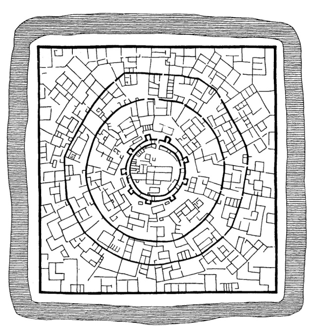
Fig. 519 – The rectangular plan of the complex Dashly-3 in Central Asia contained a circular building (after Viktor Sarianidi, 1986). The quadratic ‘temple’ city was situated on a large hill and had a rectangular wall (from 130 to 150 meters) around three concentric inner walls. A deep ditch enclosed the whole complex. The innermost part had a decorative interior and consisted of two characteristic levels, with a height difference of about fifty centimeters. The remains of a charcoal pit with the bones of animals, found in another part of the central building, could point to the use of the area as a ritual place. Furthermore, the occurrence of other fireplaces enhances the possibility of the (central) complex as a fire temple and offering place. The age is estimated as the third to second millennium BC.
A small wave of Aryan-speaking nomads from the northern steppes must have settled in a local non-Aryan culture (PARPOLA, 2003). The presence of the horse and the practice of chariot warfare are further evidence of an Indo-European origin of the new settlers (Dasa-Aryans). A second wave of settlers swept over the region in about 1700 BC (known as BMAC II).
The southern Bactrian civilization (Shortugaï, Dashly) had satellites in northern places such as Sapallitepa, Djarkutan, Boustan and Mollali. The (four) fire temples of Togolok (1300 – 1000 BC) in the country Margush (Merve) were Proto-Zoroastrian and seemed to be a direct successor of the Mesopotamian civilization in Iraq. Viktor SARIANIDI (1986; p. 64) noted the strong resemblances between the cult buildings of Baktria, Mesopotamia and Iran.
Edwin BRYANT (2001) elaborated further on the historic movement of people in these areas and the role of the Aryans in either migration towards Europe or into the Indus Valley and the Indian subcontinent. In particular the German scholars of the nineteenth century – in search of a national identity – favored an Aryan parentage. The vague term of ‘Indo-German’ was introduced in the scientific world. It pointed to a ‘homeland’ somewhere in the Caspian Sea region. The German philologist L. Geiger suggested (in 1878) that the Indo-Germanic people were blond and blue-eyed, which were subsequently ‘diluted’ with foreign genes.
The British researchers, in the light of a colonial presence in India, were also keen on drawing ethnological lines to the Aryans. The discovery of Sanskrit (in Europe) and the birth of comparative philology (linguistics) by scholars of the eighteenth and early nineteenth century put the idea of an ‘Indian homeland’ in the picture.
The scientific bickering about the ‘Aryan invasion’ in India continued in the later half of the twentieth century. In particular the conclusions drawn by certain researchers from archaeological findings (like seals, swords, pottery and copper hoards, etc.) are denied by others. Similarities of objects, sometimes found some four thousands kilometers away from each other, are used to propose migration patterns. These suggestions are then ridiculed by others (LAL, 2007).
Another remarkable building in the confines of the Daschly-3 complex is a ‘palace’ with a square building plan of 88 x 84 meters. The inner square measured 40 x 38 meters. The adjacent rooms/housings make up (in a plan) a pattern with typical tetradic connotations (fig. 520). Later additions have partly filled up the space within the central square.

Fig. 520 – The ground plan and reconstruction of the ‘palace’ of Daschly-3, a tetradic building complex from the Bronze Age in Bactria.
The ground plan is datable from c. 2000 BC and Aso Parpola sees in it ‘the prototype of the later Tantric mandalas/yantra’. This suggestion was firmly criticized by LAL (2007): ‘Must we really indulge in such a kite-flying just to support our preconceived notions?’ There are other observers (like Steve Price, 2000), who compare the floor plan of the Dashly palace with certain motifs found in textiles (fig. 521). This analogy is not too far fetched if the creativity of the people in Middle Asia is taken as a whole. The mandala and swastika (ideas) are part of a mental framework, which belong to these people in the given reality of place and time.

Fig. 521 – A comparison between the floor plan of the Dashly Palace (left) and a tetradic motif found in textiles throughout central and western Asia (right) was pointed out by Steve PRICE (2000).
Motifs in (early) Turkish and Persian carpets and kelims read like books. The ‘language’ and message depend on the region. General motifs are the ‘muska’ (amulet), bird, burdock (a plant which sticks to clothing), chest, dragon, eagle and earrings. Furthermore, the garden and panel designs are well-known for the carpets of Isfahan, Qum and Tabriz, while an overall geometric design is commonly found in the ‘Bokara’ motif (from the trading town of Bukhara (see fig. 405 for location).
Geometric patterns can also be found as illustrations on the tapestries of tribes in north-eastern Iran, Turkmenistan and along the Uzbekistan and Afghanistan border. These motifs are often derived from carpentry and are indirectly related to architecture. The so-called (Turkoman) guls (meaning ‘flower’ in Persian) always have a tetradic base and an octagonal appearance. Each tribe had its own symbolic version of a gul, although the motifs of the defeated tribes might have been used by their conquerors.
The circular complex near Kutlug-Tepe in Bactria (Northern Afghanistan) was occupied during the reign of the Achemeniden in Persia (558 – 330 BC) (fig. 522). An outer wall was built from earth blocks with spare openings of 50 x 25 cm, letting a filtered light into the first gallery. The inner gallery probably had a roof and the only light came from the outside through the checkered ‘windows’. The central part of the complex, within a circular perimeter, was occupied by a square building. This housing was (later) divided in smaller (later) compartments. The northern side showed a room with a whitewashed floor and the remains of a four-cornered (fire) altar. Viktor SARIANIDI (1986) reckoned that the complex probably had some sort of cult significance, rather than a worldly purpose.

Fig. 522 – Kutlug-Tepe is a monumental complex in Bactria (Afghanistan) dating from the first millennium BC. Sarianidi (1986) does not give the actual orientation, but it follows from his description and reconstruction that the plan, as given above, is oriented towards the north. Sarianidi’s original illustration (on page 73) was oriented towards the south and should be turned 180º.
The findings in the Bactrian-Iranian area, which can also be seen as the geographical heartland of oppositional thinking, indicate that the historical cities and buildings have a reference to the tetradic frame of mind. It might be more than a coincidence that a concentration of architectural features, which have a ‘quadralectic’ affinity, occur in this particular part of the world where the forces of opposition are so well developed.
Sarianidi’s conclusion (p. 62) is particular relevant for the present survey of tetradic testimonials in architectural history: ‘a relation between the circle (sun cult) and the altar (fire cosmology) can be noted in the given area (Bactria-Iran) with the Indo-European images as presented in the Rig Veda and the Avesta. There is also a higher connection between the square (as symbol of the four directions) and the circle (sun symbolism) in the plans of the cult buildings, which are understood as a ritual diagram and a representation of the universe and human being in all its aspects.’
This statement presents the Persian culture as an immense important focus point of the adjacent cultures, not only at the times of their highlights, but as a constant source of germination of ideas about division thinking. Maybe the ‘evolution’ of the two-fold to the four-fold can be followed clearly in this cultural presence, because the extremes (of the two-fold) are so explicitly experienced.
The geographical position of the Iranian-Afghanistan area – which is deeply continental – and its climatological characteristics might have contributed to such a cognitive setting. People living in moderate climates not far away from the sea are hardly ever prone to extreme circumstances. However, people, who are land-locked and have to face the consequences of a harsh climate, with great differences of heat and cold, will have permanent difficulties to make their lives more comfortable – which is again reflected in their psychological state of mind.
It will come to no surprise after the previous remarks, that the circle and the square are also the most basic architectonic elements in the history of the Persian culture (fig. 523). These geometrical forms are particular prominent in the places of worship (the holy fire) of the ‘chatar taq’ (four pillars). The concept has been mentioned early (fig. 406) in relation to the Mausoleum of Ismail Samani in Bukhara. Klaus SCHIPPMANN (1971; 1972) pointed to the rich field of research, which had been done, and indicated the characteristics of the fire temples in various epochs.

Fig. 523 – The circle and the square are the basic elements in (Persian) architecture are used for the building of places of worship of the sacred fire (chahar taq). The geometric figures represent two structural unities in the architectural field. The circle – leading to the dome – represents the approach to the universe and its religious connotations. The square – leading to the altar – is the limitation on earth, created in the oppositional encounter of two crossing lines.
The basic structure consists of a dome, which is placed on a square of four arches. ‘As a traditional concept of great profundity, the ‘chahar taq’ was incorporated into the world of Islamic forms where it assumed its former preeminence. Viewed through Islamic esotericism, it becomes and remains today the architectural manifestation of reintegration and of creation itself. In its forms, it embodies the most basic resolution of the square and the circle’ (ARDALAN & BAKHTIAR, 1973).
The Roman historian Herodotus, living in the fifth century BC, gave already a description of the Median capital of Ecbatana – the present Iranian town of Hamadan. The circular place was built in 715 BC. Concentric cities have been periodically encountered throughout the regions of the world and particularly on the Iranian plateau.
The circular city of Firuzabad (Iran), for instance, was built in the first half of the third century AD. The present town of Firuzabad, which means literary ‘the abode of Firuz’, is situated about hundred-and-ten kilometers south of Shiraz in the province of Fars. Five to seven kilometers to the northwest of the town are the ruins of the ancient city of ‘Ardeshir Khurra’ (‘Glory of Ardashir’ also formerly known as Gur) with a large building in the center. This rectangular building is considered to be a palace, which belonged to Ardashir I (224 – 241 AD), the first Sassanian monarch. However, the Muslim Iranian historian Ibn Istakhri described the building as the fire-temple of Ardashir. A huge stone tower now stands like an omphalos in the middle of the ruins of the town and might have been a fire tower or a commemorative structure.
The ancient city of Gur had a circular boundary, consisting of a (double) mud wall and a thirty-five meters wide ditch. The diameter of the circle was 1950 meters and the plan was divided into twenty sectors with radial concentric streets. The palace of Ardeshir over-looked a small lake and a Persian style garden enclosed the palace and its lake. The iwan or arched entry was a main building innovation during the Sassanian period, putting an emphasis on the circle and the whole in the same way as a dome.
The town of Irbil (Arbela) in Mesopotamia is another example of a concentric city. The most famous round city in the area is probably Baghad, build by Al-Mansur in the eighth century (fig. 524A-C). Al-Mansur constructed a huge round city with concentric defense walls, because the Abbasid caliphs were distancing themselves from the general populace for security reasons (RUGGLES, 2000).
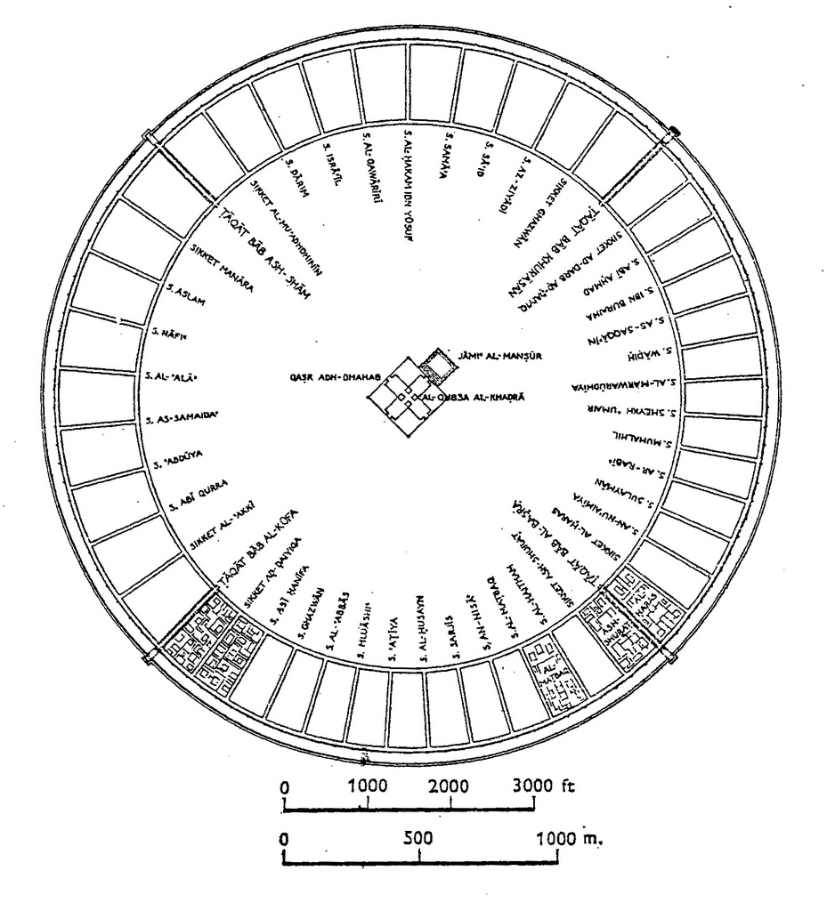
Fig. 524A – A plan of the Round City of Baghdad around 800 – 1000 AD. The city has concentric defense walls that enclosed rings of residential quarters. The palace and the mosque were right in the center point.

Fig. 524B – Baghdad – After K.A.C. Creswell. Fig. 34 in: RUGGLES, D. Fairchild (2000). Gardens, landscape, and vision in the palaces of Islamic Spain. The Pennsylvania State University Press, University Park. ISBN 0-271-01851-8

Fig. 524C – The round city of Baghdad – Fig. 9/10 in: KOSTOF, Spiro (1991). The City Shaped. Urban Patterns and Meanings Through History. A Bullfinch Press Book/Little, Brown and Company. Boston, Toronto, London. ISBN 0-8212-1867-0
The city of Takt-i-Taqdis (Throne of Arches), or Takt-I-Suleiman (see also Ch. 4.2.2.) in northwestern Iran, has reached fame as the birthplace of Zarathoustra. The palace and castle were built in the seventh century AD on the holy mountain Shiz by the Persian king Chosroes II. The city had a round shape and ‘numerous arches laid out in a particular order’.
The relation of this city to the Grail Legend is an interesting note. One legend brings the story of King Chosroes II, who conquered Jerusalem and brought many treasures with him, including Christ’s cross and the Grail. Subsequently, the Byzantine emperor Heraclius destroyed Takt-i-Taqdis in 629 AD and took the reliquaries back to Constantinople. The Crusaders in turn captured and looted Constantinople (or Istanbul) in the Fourth Crusade in 1203/1204 and took the Grail with them to the West.
Another story tells us that Christ, after he used the Grail during the Last Supper, gave it to Joseph of Arimathea, who brought the cup to England. During the reign of King Arthur in the sixth century AD the Grail was kept in Avelon (Glastonbury).
A further round form of settlement in Europe – one of many examples – can be found in Denmark near Slagelse on the isle of Seeland. It was called the Trelleborg, and can now be visited as a reconstruction of a Viking camp between 1000 and 1050 AD (fig. 525) – which is more or less contemporary with the concentric city of Baghdad. It is unlikely that the Vikings had any contact with or knowledge of the Iranian round cities, but they must have been inspired by the same idea of circular enclosure and its practical advantages.
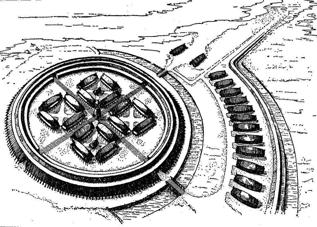
Fig. 525 – A reconstruction of a Viking settlement Trelleborg near Slagelse on the Isle of Seeland (Denmark) as it existed between 1000 and 1050 AD. The circular form has been used to provide the ultimate protection against attacks from all sides.
The round city of Citadella (Italy) was founded in 1220 as a military outpost of the city of Padua (Padova). The function of the town was to safeguard its territory against the Commune of Treviso, which was defended by the fortified town of Castelfranco. The latter (Castelfranco Veneto) is a square town, founded in 1195. Both planned towns, the circular and the square, have a ‘military’ background (fig. 526). The connection between central planning (searching for unity of the First Quadrant kind) and a defense function (dealing with a Third Quadrant unity) is clear in these two towns.

Fig. 526 – An aerial photograph of two planned town in the northern Italian plane of the River Po. Left: the round town of Cittadella. Right: the fortified town of Castelfranco Veneto with a square form. The former was built as a military outpost of the city of Padua (Padova) in 1220. The latter was a stronghold from the Commune of Treviso, founded in 1195.

Cittadella – City gate (Photo: Marten Kuilman, 2011)
The choice, at virtually the same place and time in history, for a square and circular shape, is curious and interesting in the light of the change in division thinking, which took place in Europe around the year 1200 AD (from the Second to the Third Quadrant). It is an indication that the spirit of geometry of the later (Italian) ‘Renaissance’ had its roots at the very beginning of this new period in the European cultural history, which started in what HASKINS (1927) called the ‘Renaissance of the twelfth century’. It seems that the attention to geometry is a way to deal with a change in division thinking in general and its (sign) language is a means to understand and visualize the dynamic process.
More recent examples of (semi)circular cities can be found in Amsterdam (Holland) and Cabourg (France) (fig. 527). Both cities were subject to planning and a kind of geometric vision, which resulted in a concentric configuration. Geographical restriction – like a water- or seafront – meant that the circular plan was ‘cut in half’. The city of Amsterdam got its particular lay-out in the seventeenth century, when wealthy merchants built their houses along consecutive rings of canals. Often the narrow residences also served as businesses with storage in attics and cellars.
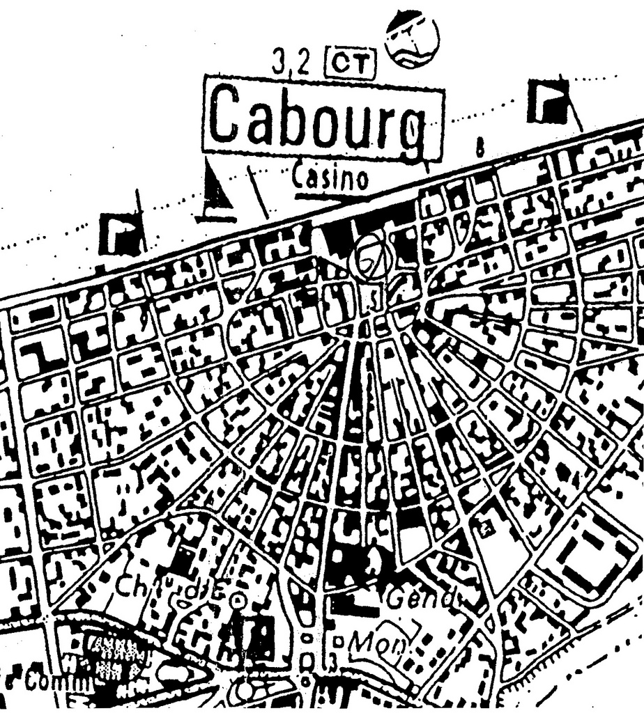
Fig. 527 – The sea side resort of Cabourg (France) is an example of a planned, half-circular town. Most of the places along the French coast had a linear lay-out along the beach.
The city of Cabourg, situated at the coast of Normandy in France, reached importance in 1853 when the Parisian solicitor Henri Durand-Morimbau started to develop the place as a spa and make it ‘la reine des plages’ (the queen of beaches). The young architect Paul Leroux drafted the fan-shaped, semi-concentric network in the winter of 1854-55. Marcel Proust (1871 – 1922), the French writer, made the place famous and was a visitor during the summer between 1907 and 1914. Here he got his inspiration for his best known book ‘A la recherche du temps perdu’, published in seven books from 1913 to 1927. The Grand Hotel with the Casino is the main buildings in the inner circle. Cabourg was part of some seven-hundred-and-fifty ‘ville balnéaire’, which were (re)developed along the French coast in the nineteenth century (TOULIER, 2009).
A typical example of a round village in modern times is the small Isla Mexcaltitan in the Nayarit province of Mexico (fig. 528). Mexcaltitan, the name meaning ‘in the house of the moon’, is the cradle of the Mexican nation. The mythical Aztlán, the origin of the Aztec people, might have originated at this location (Casa de los Mexicanos). Legend tells us that the pilgrimage to the capital Tenochtitlan (Mexico City) started from this island village. Its round shape and division with a double lined cross might have a traditional significance – which is hard to prove – but it certainly provides the present-day visitor with a unique type of village design.

Fig. 528 – The round village of Mexcaltitan (in Mexico) is an example of a circular and cross-shaped structure in Middle America. The place is situated in a shallow lake.
Another example of round communities is provided by the so-called tulou building of the Hakka and other people in the mountainous areas of southwestern China. The Hakka people were migrants from North China, who moved southwards in the later part of the Song Dynasty (961 – 1276 AD) and were content with remoter areas. In general, they were not welcomed, and they had to build their houses in a protective way. They lived in families and clans together and developed a particular concentric form of living (fig. 529).

Fig. 529 – The circular ground plan of a larger Hakka dwelling with the ancestral hall in the centre of the north side.
There are several tulou clusters, in particular in the area north of Hongkong (in Guangzhou) and in the East-Region. The ‘Fujian Tulou’ in Yongding county in the Fujian province is the most famous and consists of large multi story housing complexes. The ‘king of tulou’ is Chengqi lou at Gaotou village, which was built in 1709. It has four concentric rings surrounding an ancestral hall at the center. The outer ring is sixty-two meters in diameter and the four story’s have 288 rooms – 72 rooms on each level (fig. 530). Other clusters are at Chuxi (Xiayang Township) – with the oldest rotunda dating from 1419 in the Ming Dynasty – Zhengcheg lou (Hongkeng village), Tianluokeng, Yuchang lou and Eryi lou (Dadi Village). The latter has an outer ring of seventy-one meters with forty-eight rooms on each level.
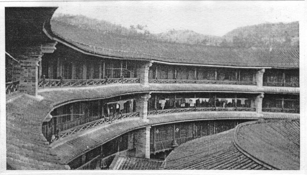
Fig. 530 – A Hakka settlement in Yongding County of the Fujian province shows circular rows of houses enclosed by a wall. The shrine of the family clan is in the middle. Photo 132 in: BOYD, Andre (1962). Chinese Architecture and Town Planning. 1500 B.C. – A.D. 1911. Alec Tiranti, London.

Drawing by Marten Kuilman.

Scheme of a Hakka dwelling. Fig. 7.52 in: STEINHARDT, Nancy (2002). Chinese Architecture. Yale University Press, New Haven and London/New World Press, Beijing. ISBN 0-300-09559-7
The Hakkas had an agricultural lifestyle and their unique architecture was based on defense and communal living. A Hakka fort could withstand a protracted siege, since its grain supply and internal water and sewage systems made them self-supporting. The origins of Hakka architecture have been traced to older forms of fortifications in southern China, as seen in the Han Dynasty and the Three Kingdoms tombs unearthed in Guangzhou, Guangdong and Ezhou in Hubei Province.
The original home ground of the Hakka people in the northern part of China exhibits – even nowadays – a particular kind of dwelling, which is called the yurt (fig. 531). Maybe this Mongolian type of (portable) building did remain in the collective memory of the Hakka people when they moved southwards in the thirteenth century. The circular idea came to good use as a defense mechanism – this time not as a protection against the harsh climate, but against the threatening behavior of fellow men.

Fig. 531 – The concentric nomadic tent, called the yurt, is a reflection of the universe.
The traditional type of tent of the Mongolian nomads consisted of a circular wooden frame, which was covered by a felt cover. The word yurt in Turkic means ‘dwelling place’ (or homeland) and its construction was steeped in symbolism. The family’s length of ownership of the tent could be measured by the number of stains accumulated on theshangrak (or central ring). The shangrak is the most crucial part of the yurt’s structure and represents the universe. The supporting woodwork of the opening is often constructed in a tetradic way. The cooking place in the middle of the tent is the ‘square of the earth’.
Alfred SCHINZ (1989; p. 372) described in his book on Chinese urbanism the gradual change from a Mongolian yurt towards a Chinese farmhouse (fig. 532). This shift from the circular to the square, as presented in this figure, looks like a reconstruction, and it is highly likely that the ‘end members’ and the intermediate forms existed together throughout time. There is, no doubt, a move in history from mobility to the sedentary type of living (of the Hakka people), which is reflected in their housing. A further study to find out how this change took place in time has to be more scientific documented to be convincing.
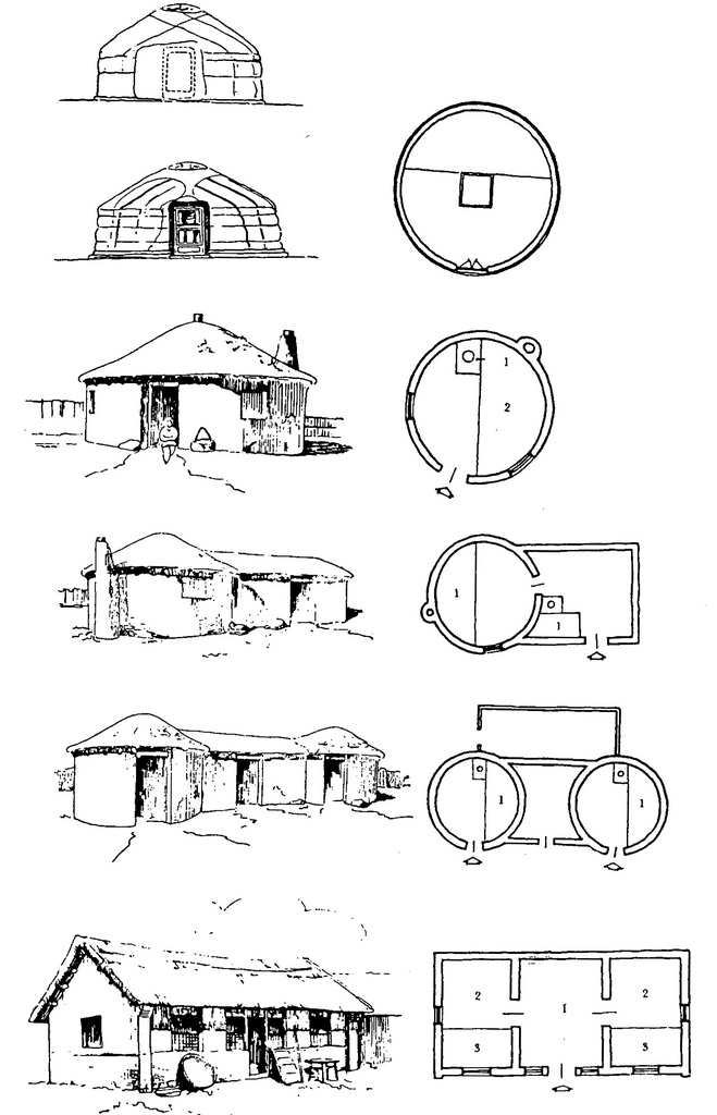
Fig. 532 – Alfred SCHINZ (1989; p. 372) proposed this change from the Mongolian yurt to a Chinese farmhouse in Inner Mongolia.
The change from the circular to the square is, in quadralectic terms, a move from the First to the Third Quadrant, from unity (I) to part (III). These settings would be regarded as ‘end members’ in an oppositional context, but not so in the cyclic context of quadralectic thinking. The latter is aware of four stages of equal importance: the unity (I), the manity (muun) (II), the part (III) and the many (IV). Any evaluation of a building structure has to take place in the sphere of these four definitions of boundaries. The yurt reflects the circularity and points to unity (I), but its awareness can ‘travel’ through the different stages in much the same way as a ‘square’ building. The yurt is also, as was mentioned earlier, embedded in symbolism and ideas (II). In its practical presence, it is just a tent (III) and, finally, it can be part of a ‘world view’, bringing the previous stages together (IV). The change from a mobile (Mongolian) yurt to a defensive (Fujian) tulou is, for that very reason, not as great as one would expect.
The story of Circleville, Ohio (USA) is the tale of a round city, which got the sack. The place, is situated some fifty kilometers south of the state capital Columbus and hundred and fifty kilometers east of Cincinnati. It has a population of 13485 people (2000). The city was established in 1810 under the direction of town director Daniel Dresbach to become the County seat of Pickaway County. He used the circular portion of a large earthwork, dating from the Hopewell era, to integrate the town plan into the existing prehistoric setting. An octagonal courthouse was positioned in the center of the town (fig. 533).

Fig. 533 – The outlay of the community of Circleville (Ohio) after it was founded along the Scioto River in 1810. The octagonal courthouse is situated in the center. This situation only lasted for some twenty-seven years, when a change in the mood of city planning began to favor the more traditional grid pattern.
The Hopewell Indians lived in the first centuries of the Christian era (Middle Woodland, 300 – 500 AD). These indigenous people probably originated from Illinois and spread through southern Indiana to Ohio, where its culture ‘found its purest expression and its most intense apotheosis’ (Olaf Prufer). Mound building and earthworks pointed to an advanced culture (or cultural complex), which grew in complexity and refinement during the Late Woodland era (500 – 1620). The earthwork, on which the later Circleville was positioned, had a diameter of 350 meters.
The circular city with its radial streets was out of fashion in the mid-thirties of the nineteenth century and the Circleville Squaring Company was established to obliterate the traces of any round planning (fig. 534). They succeeded in 1856, marking one of the earlier examples of urban re-development in the United States. This distinct change in public sympathy from the circular (I) to the square (III) in city development stands out as a rare historical event, which has to be noted in the dynamism of division thinking, which takes place in the modern American cultural presence.

Fig. 534 – The redevelopment of Circleville, Ohio 1837 – 1856 displays the gradual abandoning of the circular in favor of a square (grid) design.
A more recent example of a (re)development plan with a circular component can be found in the Armenian town of Yerivan (or Erevan) (fig. 535). This design dated from 1924 and reflects a remarkable openness and search for unity. The Communist era in Armenia started in 1922 when the country was combined with Azerbaijan and Georgia to form the Trans-Caucasian Soviet Federated Socialist Republic (TSFSR). Yerivan became the center of the new Soviet government. The occupation government promoted Armenian culture and education and a short period of optimism followed after the miseries of the Armenian people in the First World War and its aftermath.
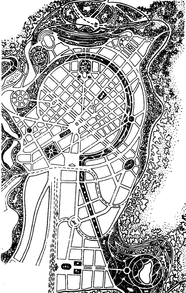
Fig. 535 – An overview of the development plan for the Armenian capital of Yerevan, as it was proposed in 1924 by the architect Alexander Tamanyan (1878 – 1936).
The architect and town planner Alexander Tamanyan (1878 – 1936) proposed a new development plan for the urban city and his work had a considerable influence on the development of the town at that time. It earned him a statue in front of the “Kaskad” (cascades) and a burial place at the Pantheon in Yerevan. The rule of Joseph Stalin (in power 1926 – 1953) changed this short post-war period of progress and replaced it by Communist political ideas, leading to a stagnant society. The building of densely populated inner cities was part of this social ideology.
The average density within the built-up area in Yerevan is 168 persons per hectare, which is more than the normal range for Western-European cities (Berlin 36; London 62, Paris 88) (BERTAUD, 2002). The higher numbers in (former) communist cities (like Moscow: 182) were the result of a particular, government-planned housing policy. This historical fact poses specific problems in the modern redevelopment programs.
The transfer of historical buildings to a corner of the city called ‘Hin Yerivan’ (Old Yerevan) are seen as an artificial effort by the new planners. These actions will not bring back the intellectual and creative life of the professionals and the artists. Instead, a familiar westernized, business-orientated architecture emerges, with its dependence on novel technologies and fashionable materials. The bankers in their pinstriped suits, which inhabit these buildings, might contribute to the financial wealth of the country, but they are not known to produce a ‘culture’. The latter is the general term for a common intellectual and spiritual identity brought about by the creative part of the population.
Tamanian’s circular design for Yerivan was predated by one year (1923) by the German architect Ernst Gloeden. He proposed nuclear towns with a circular plan (fig. 536).

Fig. 536 – This design of nuclear towns was given by the German architect Ernst Gloeden, 1923.
Yantai, a natural harbor on the northern coast of Shandong, developed in much the same way after a planning proposal from 1928 – 1930 (SCHINZ, 1989, fig. 83). It is likely that German influences played a role by the development in Yantai, since the Germans controlled the Shandong Province in the early twentieth century (1897 – 1918). Recently, China Central Television (CCTV) recognized the place as the most ‘Charming City of China’, but the round city unfortunately never materialized.
The conclusion of this short survey can be that the circular and/or radial-concentric design of larger settlements or cities is rare, in its pure form. Individual round structures, on the one hand, are well known, but extended forms of domestication along concentric plans are, on the other hand, uncommon, except for some centers in the Middle East, China and a single case in Mexico. This relative scarcity of circular cities can probably be explained by considering two causes.
The first prerequisite for a circular city is a suitable geography (the natural factor) and a deliberate plan to continue city development along concentric lines (the human factor). Ideally, the round city is situated on a plane (like those on the Iranian Plateau) without natural obstructions. These areas are common all over the world, but there are, nevertheless, very few circular cities that are built in those ideal geographical circumstances.
The absence of circular cities on a wider scale must have another reason, which has to be found in the human factor. It seems that people in power are not interested in the philosophical idea of circularity and its inherent neutrality. The combination of a strong government, which can implement ideas by force versus a non-hierarchical message of the circle-in-general is an unhappy one. Powerful governments, based on a vigorous application of law and order, are hardly ever the keepers of peaceful ideas. The main reason is, that otherwise they would not be in command.
The growth of most cities is the result of ad-hoc political decisions in a favorable economic climate. The concentric design is apparently not the first idea, which comes to mind. It needs a deliberate philosophy in a fairly unprejudiced setting. Rapid urban developments have no time for the relative luxury of philosophical considerations. Fanciful types of city layouts only come into being under special circumstances. They have their pedigree in the world of follies – a subject discussed in Chapter 3.9.4. One of the observations was the illogical element in a folly and its affinity with the Fourth Quadrant.
The quadralectic approach to architecture can explain why circularity is not directly considered in building plans. The four-fold setting gives rise to a normal progression from intentions (First Quadrant), creative ideas (Second Quadrant) to visible building (Third Quadrant). The symbolic language of architecture becomes an important tool in the ‘last stage’ of the quadralectic communication (Fourth Quadrant) when the importance of the division environment is understood.
Dualistic city developers and builders do not grasp this advancement and remain in the rigid chains of opposition. The visible presence (in the Third Quadrant) aims at distinction, if not might. Like the Abbasid caliph Al-Mutawakkil said: ‘Now I know that I am indeed a king, for I have built myself a city and live in it’ (CRESWELL, 1989). The caliph made this statement after he moved into the city of al-Jafariya, north of Samarra. He only lived there some nine month before he was assassinated in 861 AD. (RUGGLES, 2000).
Higher division thinkers are able to see a direction away from limitations imposed by conditions in a lower division. Squareness (III) can move into a Fourth Quadrant (IV) to become part of a set of dynamic relations. A different position of duality will give the oppositional forces a fresh meaning. They can even reach into the realm of a consecutive First Quadrant – and disappear in circularity. Many options, forwards and backward, are open. It is even possible – in an oppositional setting – that the preference of the circle as an architectural feature is the result of a resistance and opposition against squareness.However, the circle is also – in a non-oppositional ambiance – the beginning (or end) of a path of insight.
These different elements might have played a role in the concentration of circular cities on the Iranian Plateau and Mesopotamia. The psychological hallmark of the people in this area is a distinct oppositional mind. Their dedication to carpet weaving has earlier been mentioned as a proof of a rift in time consciousness between the extremely short (the act of weaving) and very long (the consciousness of beauty).
This very condition produced, in the long cultural history of this geographical area, a frame of mind, which has similarities with the quadralectic way of thinking. The feelings of static opposition (two-fold thinking) can expand into dynamic interactions. The visible invisibility of the Fourth Quadrant looses its expression in the invisible invisibility or eternal disposition of the First Quadrant. The symbol of the former (IV, water) evaporates by the expression of the latter (I, fire), captured in a circle, a ring of fire.
A rather bizarre development within the history of architecture is the project of Himmler in Wewelsberg near Paderborn (Westphalia). Heinrich Himmler, the right-hand of Adolf Hitler and organizer of the ‘final solution’ for the Jews, transformed the old castle into an Ideological Centre of the Waffen SS. Himmler purchased the ruined castle, which was originally built between 1603 – 1609 by Herman Baumhauer, in 1934. A concentric plan was used in the subsequent development of the area around the castle (fig. 537).

Fig. 537 – The Nazi SS chief Heinrich Himmler developed, between 1941 and 1944, a cult centre for the SS party in the Wewelberg Castle near Paderborn (Germany).
The neo-paganism of the Nazi Party and the ensuing regime influenced the thinking of the German people during their years in power. In particular certain ‘Aryan’ ideas – concerned with oppositional thinking and identity – were incorporated in the Nazi philosophy. The relation with the earth (‘Blood and Soil’), rural life and a ‘back-to-nature’ spirit led to a fierce nationalism. Secret societies, like the ‘Germanenorden’ and the Thule Society, were playgrounds to practice the mechanisms of power. The extermination of the Jews in later years can, in hindsight, be seen as an (European) obsession with identity.
The SS (Schützstaffel) was modeled on the Teutonic Knights, an offshoot of the Knights Templar, known of the Holy Grail. A whole fictional framework was designed to replace Christianity and rewrite history. The old sun-sign of the swastika – which is the acknowledged symbol of a dynamic four-division – got an ill reputation from which the cultural conscience of Europe is still not completely recovered. The focal point of the Wewelsberg Castle was a huge round oak table with twelve chairs. Beneath this room was a crypt, where a holy fire kept on burning all the time. This place was seen as the midpoint of the earth.
Another major Nazi cult center, also founded in 1934 (Stiftung Externsteine), was the natural exposure of the Externsteine near Horn/Bad Meinburg, in the Teutoburger Wald (fig. 538). Here, four spectacular columns of sandstone rock are said to include the famous sacred pillar of the Saxons, Irminsul. However, this link could not be supported be archaeological evidence, because only some pottery from the seventh century was found and the majority of artifacts dated from the eleventh to fourteenth centuries.

Fig. 538 – The prominent rock formation of the ‘Externsteine’ near Horn/Bad Meinburg and the city of Paderborn (Germany) were seen by the Nazi party as a cult center, including the Irminsul, the sacred pillar of the Saxons. Archaeological research in the years before the Second World War did not confirm these speculations.

The Exernsteine near Paderborn (Germany) – Photo: Marten Kuilman (2006).
So, in the end, the circular city might be a form of representation of the (first part of the) Fourth Quadrant spirit, but it is also haunted by a mirage of ideas, which find their base in oppositional thinking. The circular, when used to enhance the feelings of identity, is heading for muddy waters. This same situation occurs, as a matter of fact, with a celebration of the sign of the cross – which is still encouraged by the Roman Catholic Church and other creeds. Any misuse of the circular (or cross) – as a reaction against something else or to enhance a particular form of (visible) visibility – is missing the point of genuine quadralectic thinking.
Therefore, the interpretation of the cyclic-in-general – including the layout of a city – has to be treated with caution. Not all cyclic phenomena are born in a true quadralectic spirit. They might as well be the result of consequent oppositional (Third Quadrant) thinking, without ever reaching the realm of higher division thinking. The (circular) Iranian cities, in the heartland of dualism, may not be so ‘quadralectic’ after all. And Himmler’s concentric extensions of the Wewelsberg Castle certainly do not qualify to be created in the setting of equality and wholeness of the Fourth Quadrant.
